 TemperateReefBase Geonetwork Catalogue
Temperature of the water body
Type of resources
Topics
Keywords
Contact for the resource
Provided by
Years
-
This in situ temperature data was collected from HOBO pendent loggers at Cayo Mario and Cayo Enrique, La Parguera, Puerto Rico, from 06/30/2017 to 06/20/2019. The loggers were placed at different depths around the reefs, and the goal was to compare the in situ temperature to satellite SST to see how representative the satellite SST was of the temperature at the depth of the corals.
-
Temperature loggers have been deployed at a range of sites statewide in waters ranging between 6 and 22m depth. From 2012, 27 sites around Tasmania are being monitored. This record shows data collected from 2004 up to December 2020. Data is still being collected (April 2023) and will be added to this collection as it becomes available.
-
The occurence and distribution of zooplankton species off the east coast of Tasmania was investigated between 1971 and 1973. Samples were collected at stations distributed along three transects extending seaward. Temperature and salinity data was collected at the same time.
-
Zooplankton samples were collected at inshore coastal waters of south eastern Tasmania, between the years 1971 and 1972. Three stations were selected to cover the D'Entrecasteaux Channel, mouth of the Derwent River and the Storm Bay areas. Surface, midwater and bottom zooplankton samples were collected monthly for a period of twelve months during the day as well as night time, using horizontal tows. Data for temperature and salinity were also obtained from the stations.
-
The dynamics of carbonate system of a coastal coral reef system under the influence of submarine groundwater discharge in Sanya Bay in the northern South China Sea were investigated using time-series observation.
-
The Oliver and Holbrook (Journal Atmospheric and Oceanic Technology, 2014), or OH14, data set provides spatially and temporally homogeneous measurements of sea surface temperature (SST) variability at high resolution on the continental shelf around Australia.
-
This study considered a range of water-column and sediment (benthos) based variables commonly used to monitor estuaries,utilising estuaries on the North-West Coast of Tasmania (Duck, Montagu, Detention, and Black River). These included: salinity, dissolved oxygen, turbidity, nutrient and chlorophyll a levels for the water-column; and sediment redox, organic carbon content, chlorophyll a and macroinvertebrate community structure amongst the benthos. In addition to comparing reference with impacted estuaries, comparisons were also made across seasons, commensurate with seasonal changes in freshwater river input, and between regions within estuaries (upper and lower reaches) - previously identified in Hirst et al. (2005). This design enabled us to examine whether the detection of impacts (i.e. differences between reference and impacted systems) was contingent on the time and location of sampling or independent of these factors. This data includes sampling from Duck River, Montagu River, Detention River, and Black River.
-
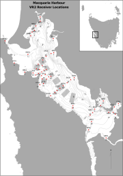
Fixed position oxygen and water temperature logger data from the Macquarie Harbour World Heritage Area (WHA). Two Hobo oxygen data loggers are positioned at approximately 15 m depth at different sites within the WHA, with the intent of monitoring representative mid-bottom water oxygen values in the WHA as these were identified in previous studies to be naturally low due to limited seawater exchange at the harbour entrance, and thus likely to be most susceptible to anthropogenic factors that may increase oxygen demand and alter WHA conservation values. These values include core habitat of the Maugean Skate, a listed threatened species. This work is funded by WHA advisory board via the Nature Conservation Branch of DPIPWE and is part of a larger study being conducted by IMAS undertaking a biological baseline study of the biodiversity of the Macquarie Harbour WHA. This data spans 08/11/14 to present (most recent update 02/02/17).
-
A 12-month program was developed and implemented in order to obtain baseline information on water quality (salinity, water temperature, dissolved oxygen, turbidity, pH, dissolved nutrients, silica), ecological condition as shown by Chlorophyll a, benthic macroinvertebrates, pathogens, and habitat extent determined from habitat mapping. Five key estuaries and coastal waters were assessed in the Southern NRM Region of Tasmania. This data includes sampling from Pitt Water / Orielton Lagoon, North West Bay, Port Cygnet, Little Swanport, Moulting Lagoon / Great Swanport.
-
Physical and chemical parameters at five Pacific oyster (Crassostrea gigas) growing areas in Tasmania - Pittwater, Pipeclay Lagoon, Little Swanport, Georges Bay and Simpsons Bay - were measured as part of a study to determine the carrying capacity of the areas for oyster farming. This has provided valuable environmental data for these areas. The hydrodynamic regimes at each area except Simpsons Bay were studied, including high and low water volumes, flushing rates, flow rates and depth contours. Temperature, salinity and concentrations of nitrates, phosphates, silicates and chlorophyll a were measured monthly at several sites in each area. The change in these parameters over different time scales also was examined at two sites in Pittwater and indicated temporal and spatial variability in the environmental parameters measured.